Google Maps Is Testing New AR Walking Navigation
Dhir Acharya - Feb 12, 2019
The feature will reportedly guide users to their destinations more efficiently. Google is currently releasing the feature to a group of users.
- Mysterious Places That Are Blurred Out On Google Maps
- You Can Now Know Your Exact Location With Google's Live View
- Google Maps Helps You Find Food And Night Shelters Across 30 Cities Amid CO.VID-19
Google Maps may soon add augmented reality to its mobile app.
On Monday, the company announced that it’s doing tests on an update for the walking navigation feature on its app. With this new update, users can find their way based on the phone’s camera and arrows.
Although the search giant had already unveiled this feature in May, during its I/O developer conference, this time, it’s releasing the update to a handful of the app’s Local Guides. This is a user community of Google Maps that volunteer to provide local information about businesses as well as test out new features. The company doesn’t plan to test the update at a broader range.
This new navigation feature is meant to help users orient themselves while following Google’s walking maps. Furthermore, it helps solve a common problem users face in big cities: getting out of a subway and not knowing which direction to head, they wait for a tiny blue dot on the app to tell them where to go.
Google Maps product manager Joanna Kim said on Monday:

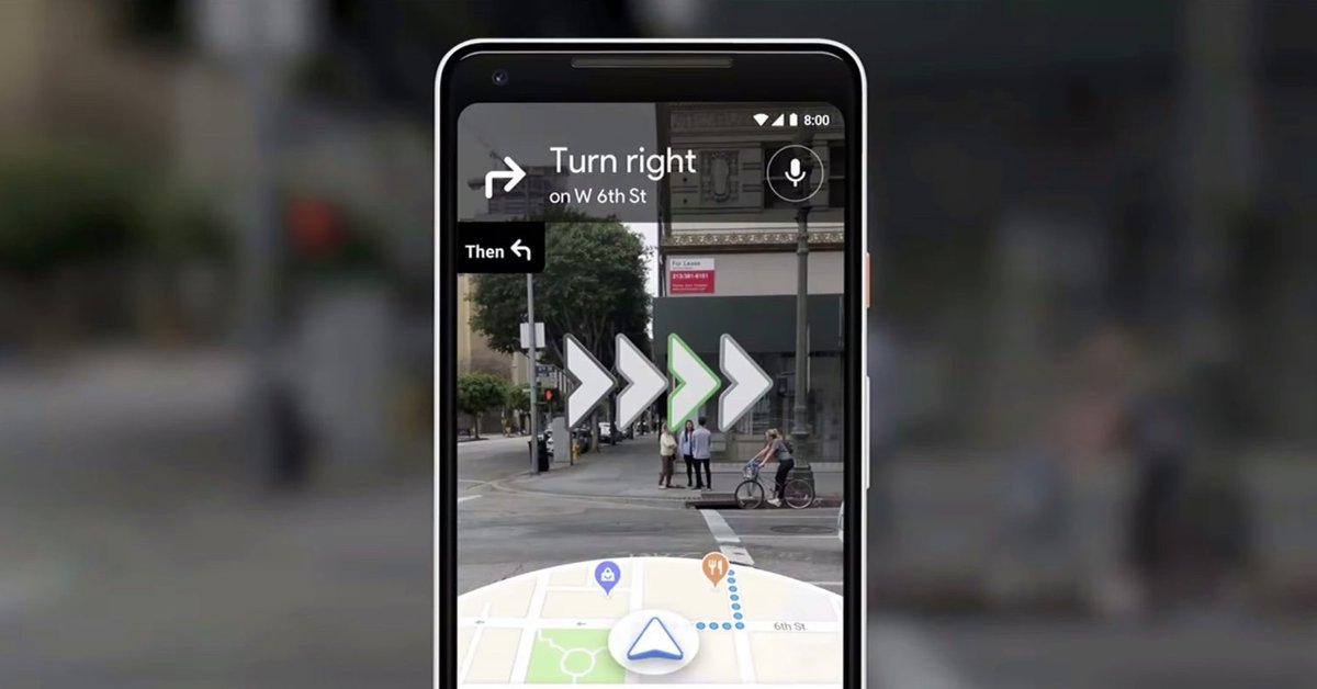
And this is how the feature works. First, input an address into the search box in the app, select the walking mode, and click on a button to begin the augmented reality functions.
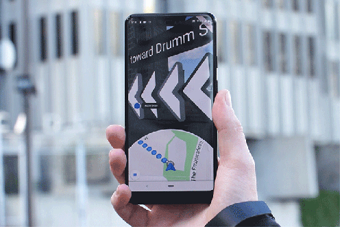
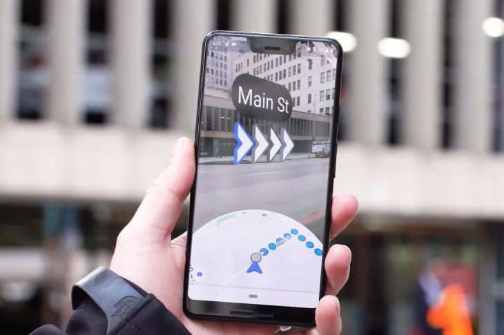
Now, hold the phone facing you, the top of the phone screen will display a camera view while the bottom will display a traditional map. When you’re close to a turn, there will be a vibration from the phone and arrows on display telling you where to go.
It’s not compulsory to hold up the phone all the time considering how dangerous that would be, but at certain parts of the route: when starting the trip, confirming a turn, or finding the way into a building. In fact, the app will give a warning when you’re staying too long in AR mode. When you reach your destination, a red pin will show up on the camera screen.
To make the feature possible, Google combines GPS data grabbed from satellites and cell towers with its own data from the Street View maps.
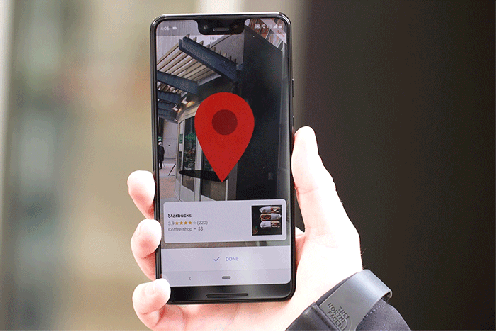
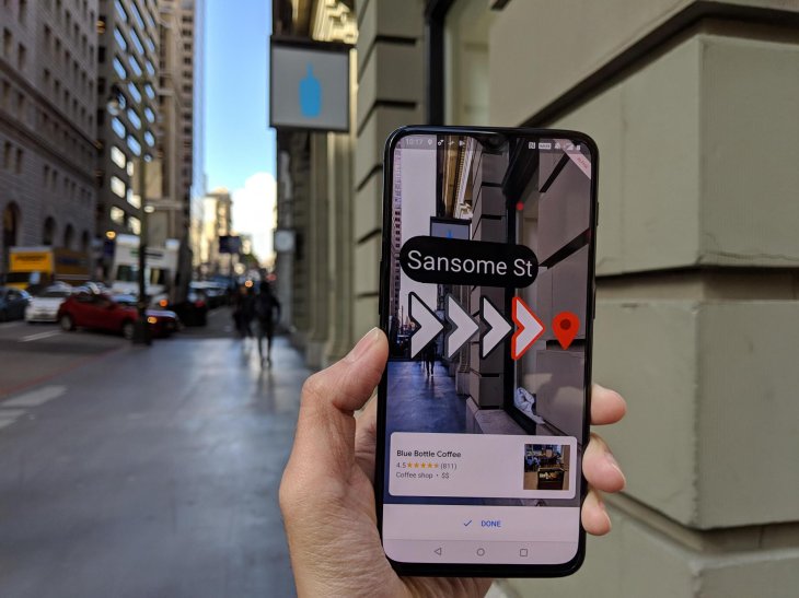
A red pin pops up when users arrive at the destination
Also on Monday, Google invited a few reporters to try out the feature, who met at a place and followed directions in AR mode to a coffee shop. The walk took 17 minutes. In general, the feature worked well despite some hiccups. At some turns, the arrows took a while to show up on the phone screen. And while the reporters were heading straight forward, at one point, the traditional map suddenly veered left. It’s also worth noting that low light condition may affect the feature’s accuracy.
Back in May, when showing a demo video of this navigation feature, Google also showcased a mode with a 3D animated fox to guide users. Google did not release that mode for testing this time, Kim explained that because the cute fox may distract users.
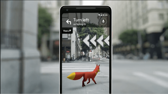
A mode that includes a guiding 3D fox
Interestingly, Google hinted that its visual search tool Google Lens will be integrated into Maps, by which you can see information on the nearby businesses. The product is still at the prototype phases, according to Kim.
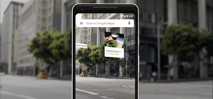
Maps will be integrated with Google Lens
Featured Stories

ICT News - Jul 29, 2026
The RAM Crisis: Graphics cards shoot up in prices again

ICT News - Jun 27, 2026
OpenAI Launches Limited GPT-5.6 Preview Amid U.S. Security Review

ICT News - Jun 16, 2026
Elon Musk Becomes World's First Trillionaire After SpaceX's Record IPO

ICT News - Jun 14, 2026
The Technological Revolution at the 2026 FIFA World Cup

ICT News - Jun 03, 2026
Apple's Liquid Metal Hinge Poised to Deliver Breakthrough for Foldable iPhone...

ICT News - May 29, 2026
New Glenn Rocket Explodes in Massive Fireball During Static Fire Test at Cape...

Mobile - May 24, 2026
iOS 27 Preview: Apple Delivers Its Most Intelligent Siri Yet Alongside Fresh AI...

ICT News - May 08, 2026
Elon Musk Highlights Neuralink Breakthrough with New Surgical Robot for Brain...

ICT News - Apr 13, 2026
DDR4 RAM Prices Finally Fall After Soaring More Than 2,200 Percent

ICT News - Apr 06, 2026
Artemis II Crew Enters Moon's Gravitational Sphere on Historic Day 5
Read more
ICT News- Jul 29, 2026
The RAM Crisis: Graphics cards shoot up in prices again
Until memory production capacity catches up, graphics cards are likely to remain more expensive than many enthusiasts hoped.
Comments
Sort by Newest | Popular