Facebook To Roll Out AI Tool For OpenStreetMap Users
Anil - Jul 24, 2019

A new AI-based technology which is applied to OpenStreetMap will help volunteers to find an easier way to add unmapped areas.
- Palantir CTO Identifies Iran Conflict as First Large-Scale AI-Driven War
- AI's Role in Warfare: US Strikes on Iran Unveiled
- Elon Musk's Bold Chip Venture: Tesla's Massive Fab Initiative Sparks AI Hardware Competition
Although you can easily enter an address into a map service like Google Maps or Apple Maps and find out the exact location in a matter of seconds, there's still a slew of uncharted roads and territories. However, a new AI-based technology from Facebook which is applied to OpenStreetMap is likely to help volunteers to find an easier way to establish unmapped areas.
Facebook has already announced the Map with AI technology to the OpenStreetMap community. Thanks to it, everyone can take advantage of it to discover specific areas in some countries, including Bangladesh, Indonesia, Afghanistan, Uganda, Tanzania, Nigeria, and Mexico. However, the base number will be expanded to cover the world.
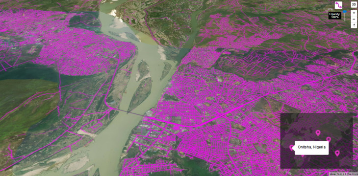
To solve numerous issues related to the mapping process, the tech giant will recognize paths on the Earth by using images with a high resolution from satellites, two square feet per pixel. From that, the neural network will be able to detect unpaved roads and pedestrian walkways as well as distinguishing them from other things. Lastly, volunteers will do the final verification.
Apart from Map with AI, Facebook also introduced a tool called RapiD, which is said to be an advancement of the current editor. The new editor will allow mappers to "mapping" new roads more quickly. As of now, OSM is the largest source of open-source mapping data in the world, and Facebook is totally reliant on it for its maps-driven services, especially its Marketplace, Check-ins, and Facebook Local.
Featured Stories
ICT News - Jul 29, 2026
The RAM Crisis: Graphics cards shoot up in prices again

ICT News - Jun 27, 2026
OpenAI Launches Limited GPT-5.6 Preview Amid U.S. Security Review

ICT News - Jun 16, 2026
Elon Musk Becomes World's First Trillionaire After SpaceX's Record IPO

ICT News - Jun 14, 2026
The Technological Revolution at the 2026 FIFA World Cup

ICT News - Jun 03, 2026
Apple's Liquid Metal Hinge Poised to Deliver Breakthrough for Foldable iPhone...

ICT News - May 29, 2026
New Glenn Rocket Explodes in Massive Fireball During Static Fire Test at Cape...

Mobile - May 24, 2026
iOS 27 Preview: Apple Delivers Its Most Intelligent Siri Yet Alongside Fresh AI...

ICT News - May 08, 2026
Elon Musk Highlights Neuralink Breakthrough with New Surgical Robot for Brain...

ICT News - Apr 13, 2026
DDR4 RAM Prices Finally Fall After Soaring More Than 2,200 Percent

ICT News - Apr 06, 2026
Artemis II Crew Enters Moon's Gravitational Sphere on Historic Day 5
Read more
ICT News- Jul 29, 2026
The RAM Crisis: Graphics cards shoot up in prices again
Until memory production capacity catches up, graphics cards are likely to remain more expensive than many enthusiasts hoped.
Comments
Sort by Newest | Popular