How Google Maps Recognizes And Shows Traffic Jams On Its Map
Dhir Acharya - Feb 08, 2020

Recently, an artist used 99 iPhones to create a fake traffic jam on Google Maps, which make many of us question how Google Maps recognizes traffic jams.
- Mysterious Places That Are Blurred Out On Google Maps
- You Can Now Know Your Exact Location With Google's Live View
- Google Maps Helps You Find Food And Night Shelters Across 30 Cities Amid CO.VID-19
Recently, an artist made headlines when he confused Google Maps by creating a fake traffic jam using 99 iPhones running the app at the same time as he dragged them around the city. While this incident is amusing and quite a trick, it makes many people question how the platform tracks, responds to the data it gathers in traffic conditions. If a regular user can fool Maps that easily, can we really trust it?

How traffic jams appear on Google Maps
The platform refreshes continually based on the user data it tracks anonymously, traffic sensors, as well as satellite data to ensure the highest data accuracy possible.
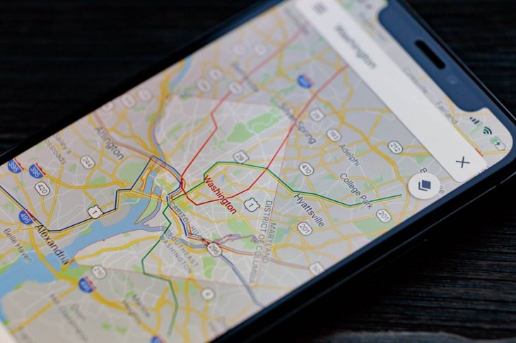
If you have used Google Maps, you may have noticed that it colors streets in red, orange, and green. The green color is used when the traffic is moving normally while red and orange mean the traffic is moving slowly, meaning users in navigation mode are moving at a speed lower than usual. This rule is applied automatically by Google. But if other drivers using the app can get through an area at their normal speeds, Google Maps removes the slow down status for this area, even if they are driving slower.

It isn’t clear how many slower-than-usual drivers are needed to be recognized as slow traffic. However, a report from 9to5Google on the artist’s experiment said that it took just one car driving past another at a normal speed to change the status of the traffic caused by his iPhones.
More importantly, Google seems to ignore when many users are not moving. The artist had to move the iPhones so that Google Maps recognizes the traffic jam although all the 99 iPhones were using navigation mode and weren’t moving. It’s also unclear how long a vehicle must stay still until the Maps ignores.
It's apparent that the Maps will notice when many users stop on a highway, reporting it as a slowdown. However, if several people park in a parking lot and the navigation mode is accidentally on, the Maps may not recognize it was a traffic jam.
One interesting thing is that Maps doesn’t treat the same to all vehicles. It can distinguish cars from motorcycles as well as other vehicles. So, even when a scooter can get through a traffic jam, Google Maps may not change the traffic status.

Accidents, construction, and other incidents in traffic
In addition, Google Maps updates report on traffic using user input apart from passive, along with anonymized movement and location tracking to keep conditions updated.
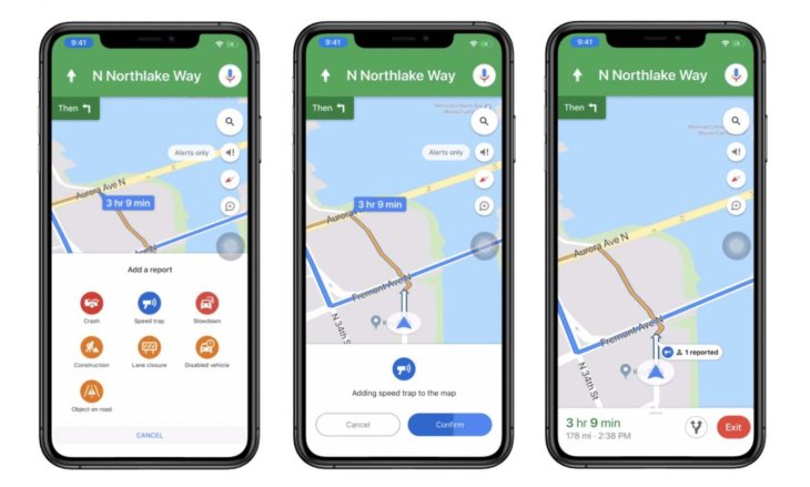
Users can report speed traps, construction zones, accidents as well as other alerts on Google Maps, the more users report one incident, the faster it will appear on the map, helping others save time by avoiding the route.
In case you ever want to report something to Google Maps, here’s how:
- In the navigation mode in the map, tap on the ‘+’ icon.
- Select the kind of incident you want to report. Then follow the instructions to complete the submission.
- The app will start adding your report to the map.
>>> Man Uses 99 Phones To Fake Traffic Jam On Google Maps
Featured Stories

Features - Jan 29, 2026
Permanently Deleting Your Instagram Account: A Complete Step-by-Step Tutorial

Features - Jul 01, 2025
What Are The Fastest Passenger Vehicles Ever Created?

Features - Jun 25, 2025
Japan Hydrogen Breakthrough: Scientists Crack the Clean Energy Code with...

ICT News - Jun 25, 2025
AI Intimidation Tactics: CEOs Turn Flawed Technology Into Employee Fear Machine

Review - Jun 25, 2025
Windows 11 Problems: Is Microsoft's "Best" OS Actually Getting Worse?

Features - Jun 22, 2025
Telegram Founder Pavel Durov Plans to Split $14 Billion Fortune Among 106 Children

ICT News - Jun 22, 2025
Neuralink Telepathy Chip Enables Quadriplegic Rob Greiner to Control Games with...

Features - Jun 21, 2025
This Over $100 Bottle Has Nothing But Fresh Air Inside

Features - Jun 18, 2025
Best Mobile VPN Apps for Gaming 2025: Complete Guide

Features - Jun 18, 2025
A Math Formula Tells Us How Long Everything Will Live
Read more

Mobile- Feb 16, 2026
Xiaomi Launches Affordable Tracker to Compete with Apple's AirTag
For users tired of ecosystem lock-in or high prices, the Xiaomi Tag represents a compelling, no-frills option that delivers core functionality at a fraction of the cost.

Mobile- Feb 14, 2026
Android 17 Beta 1 Now Available for Pixel Devices
While Android 17 Beta 1 doesn't introduce flashy consumer-facing changes yet, it lays the groundwork for a more robust and flexible platform.

ICT News- Feb 15, 2026
X Platform Poised to Introduce In-App Crypto and Stock Trading Soon
X has been laying the groundwork for this expansion.
Comments
Sort by Newest | Popular