Ground-Penetrating Radar Reveals A 2,200-Year-Old Roma City
Dhir Acharya - Jun 09, 2020
For the first time ever, ground-penetrating radar was used by archaeologists in mapping an entire city while it remains beneath the ground.
For the first time ever, ground-penetrating radar was used by archaeologists in mapping an entire city while it remains beneath the ground.
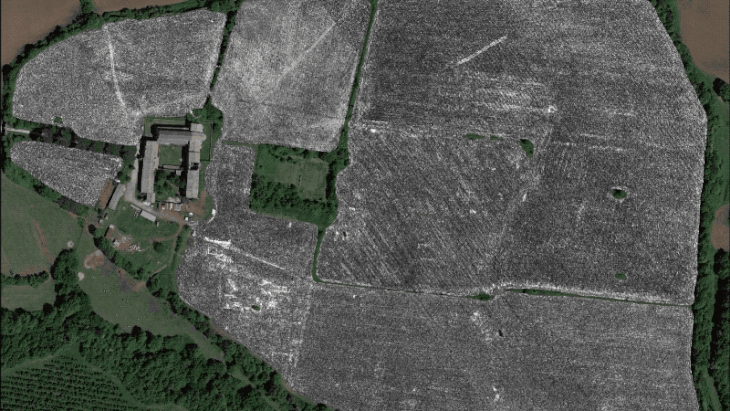
They have compiled a preliminary map of the ancient Roman city Falerii Novi, 50 km from Rome, using the data collected by the ground-penetrating radar. According to the study’s co-author Martin Millett, the map is considered preliminary as human researchers couldn’t analyze all the 28 billion data points gathered during the project.
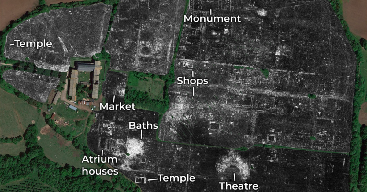
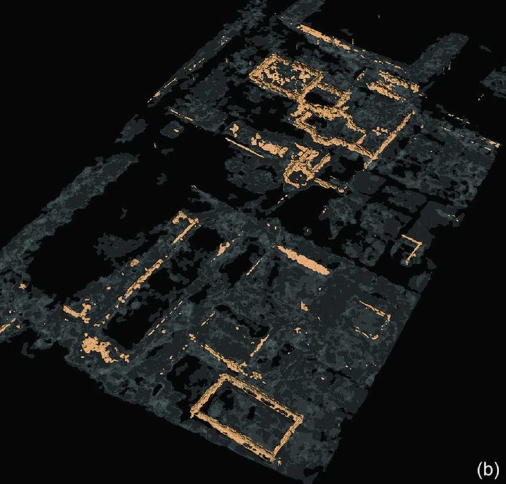
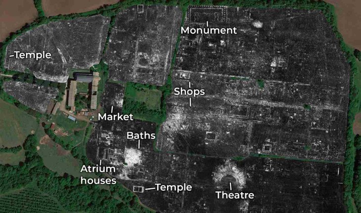
The researchers managed to document the locations of passageways, monuments, buildings, and water pipes without even picking up the trowel. Not just documenting these architectural features, which was previously unknown, but the scientists could also record the changes to the city in chronicle order and noticed unique elements that hadn’t been seen in ancient Rome before.
Falerii Novi is documented well in historical accounts, it represents one of the 2,000 cities around the Roman Empire. It appeared in 241 BCE, occupied till the Medieval period, and was abandoned in around 700 CE.
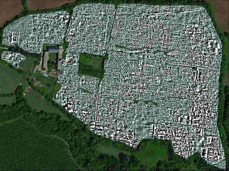
To map the city, a rig equipped with ground-penetrating radar was towed by an all-terrain vehicle across a 75-acre site, the scientist scanned every 12.5 centimeters of the area. Falerii Novi was chosen for testing the technology because it isn’t obscured by forests or a newer structure.
Using the radar scans, the team was able to document a market, a bath complex, an outdoor theater, shopping area, atrium homes, the periphery, and a pair of temples. The archaeologists also found a large public monument that has two structures facing each other, featuring a configuration not seen anywhere else in ancient Rome. Millett said:
“Part of the importance is that our survey is showing us an ordinary Roman town in Italy, not a special town—but it is extremely impressive to see this level of architectural detail across the whole site.”

Falerii Novi featured an unorthodox layout and seemed less standardized than other cities of ancient Rome. Previous work with magnetometers identified sacred spaces in the city while the new method identified large buildings in the marginal space next to the gates of the city. The researchers wrote in their study:
“Although we are yet to understand how this sacred landscape functioned, the survey provides new insights into the variety of planning concepts underlying what are sometimes incorrectly considered to be ‘standardized’ Roman town plans. By providing a contrast with more familiar towns such as Pompeii, this work also raises important questions about the planning of Roman towns more generally.”
To analyze the huge amount of data, the team is working on an automated process involving object detection using the computer, which could lead to further discoveries and insights.
>>> 20,000 Tons Of Oild Spilled Turned The Arctic Circle Blood Red
Featured Stories

Features - Mar 24, 2026
How to Use GeForce NOW to Play Video Games Without Actual Hardware

Features - Jan 29, 2026
Permanently Deleting Your Instagram Account: A Complete Step-by-Step Tutorial

Features - Jul 01, 2025
What Are The Fastest Passenger Vehicles Ever Created?

Features - Jun 25, 2025
Japan Hydrogen Breakthrough: Scientists Crack the Clean Energy Code with...

ICT News - Jun 25, 2025
AI Intimidation Tactics: CEOs Turn Flawed Technology Into Employee Fear Machine

Review - Jun 25, 2025
Windows 11 Problems: Is Microsoft's "Best" OS Actually Getting Worse?

Features - Jun 22, 2025
Telegram Founder Pavel Durov Plans to Split $14 Billion Fortune Among 106 Children

ICT News - Jun 22, 2025
Neuralink Telepathy Chip Enables Quadriplegic Rob Greiner to Control Games with...

Features - Jun 21, 2025
This Over $100 Bottle Has Nothing But Fresh Air Inside

Features - Jun 18, 2025
Best Mobile VPN Apps for Gaming 2025: Complete Guide
Read more

Mobile- Apr 26, 2026
Google Pixel Battery Scandal Illustrates Why Capacity Rules the Smartphone Market
Google Pixel Battery Scandal Illustrates Why Capacity Rules the Smartphone Market

Mobile- Apr 27, 2026
RGB Notification Lights Make a Triumphant Return on Xiaomi's Poco X8 Pro
Xiaomi has delivered a refreshing surprise in the crowded mid-range smartphone market with its latest Poco X8 Pro.
Comments
Sort by Newest | Popular